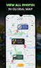


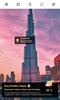

GPS Cam : Map & Photo Location combines the functionality of a GPS tracker and a camera to enhance your photos with precise location details and weather information. This innovative tool allows you to capture images with added metadata such as latitude, longitude, address, and real-time weather. It also lets you overlay this information onto existing photos from your gallery, making it an ideal solution for both personal and professional use.
Versatile Tool for Various Users
The app proves to be a valuable asset across diverse industries, including farming, civil engineering, architecture, and military operations. By combining site location with visual documentation, you can seamlessly share essential details with colleagues or clients. Additionally, it is perfect for travelers who want to preserve memories by documenting visits to specific places with timestamps and contextual data.
Customization and Advanced Features
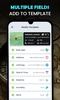
GPS Cam : Map & Photo Location offers extensive customization options to suit your preferences. You can modify layout types to include details such as the map, weather, or address while adjusting the colors or opacity for a personalized touch. The app also lets you use various map types, whether normal, satellite, terrain, or hybrid, to enhance your visual content. With options like voice-search-based location tagging and saved history, it ensures an intuitive and streamlined user experience.
Make your images more informative and engaging with GPS Cam : Map & Photo Location. From personal travel memories to professional documentation needs, this app seamlessly integrates mapping and photography for versatile applications.
Requirements (Latest version)
- Android 6.0 or higher required
Comments
There are no opinions about GPS Cam : Map & Photo Location yet. Be the first! Comment